


This page was last updated on 11 June, 2017.
Mt. Sinai located #1
1. So much to choose from…
On the page titled “Mountain of Fire” it was established that Mt. Sinai was an active volcano. Unfortunately that doesn’t do much to narrow down mt. Sinai because there are hundreds of volcanoes in Arabia. Even in Midian there are several.
2. Collecting location hints
- The Arabic words harna, harnah and harrat all mean lava field.
- Harrat is also use to name a lava field. Harrat Mt. Sinai would means the lava field belonging to a volcano named Mt. Sinai.
- Mt. Horeb = Mt. Sinai = Mt. Serabit
- Deut 1:2 It is eleven days from Horeb by the way of mount Seir to Qadesh Barnea.
- A stream is coming down from the mountain.
Deut 9:21 I took your sin, the calf you had made, and burned it up in the fire, beat it to pieces, and ground it up still smaller, until it was as fine as dust; then I threw its dust into the stream coming down from the mountain.
2a.The road from Seir to Qadesh Barnea
Moses said, if you get on the road named ‘way of mount Seir to Qadesh Barnea’ and traveling from at Quadesh Barnea, for 11 days then you get close to Horeb where I’m right now.
A days journey depended on several factors.
- People walked faster on a good flat road than on a bad uphill road.
- Often they traveled from water source to water source. Those were never spaced out at a certain exact distance.
So a day’s journey varied in length. We don’t know (yet) if they traveled from well to well or packed several days of water on their donkey’s. 28-
2a1. Qadesh Barnea
Qadesh Barnea is a regio around a small spring named ‘Ain Quideis’ according to many scholars.
The Arabic spelling of Qadesh is Qudeis.
BDB Definition:
Kadesh-
1) a city in the extreme south of Judah
1a) same as ‘Kedesh’ and ‘Kadesh’
Most scholars agree the spring is located 50 miles southwest of Beersheba
Bedr → Mu’azzam = 37 miles.
Mu’azzam → Akhdar = 35 miles.
Akhdar → Tabuk = 39 miles.
Tabuk → Hazm = 25 miles.
Hazm → Hajj = 31 miles.
Hajj → Sorer = 25 miles.
Sorer → Akabat = 31 miles.
Akabat → Maan/Mt. Seir = 37 miles.
Maan/Mt. Seir → Petra = 24 miles.
Petra → Mazad Neqavot = 34 miles.
Mazad Neqavot → Kadesh Barnea = 34 miles.
—–––– +
Total: 352 miles
2a2. An assumption
Let’s draw a circle a 412 mile radius, with it’s center exactly on the spring named ‘Ain Quideis’.
Mt. Sinai must be somewhere in that circle.
IF the road was exactly straight and flat. The chances for that are zero.
So the circles needs to be smaller but it’s impossible to say how much smaller.
Likewise we can draw the smaller 308 mile circle. But that one needs to be smaller for the same reason. If we ignore that for a moment we know mt. Sinai is somewhere in the area between the circles.
But because we don’t know how much smaller the small circle needs to be it can only be used as a rough guide. That means it’s very well possible for example mt. Sinai is only 260 from the spring. In a straight path.
If Moses measured from another point like the edge of the region then the estimates can be wrong by many miles!
Obviously we can rule out the majority of the circle because for example the Northern part is in Israel and a large part of the western side in the Mediterranean Sea.
On the map below I’ve draw a circle with a 412 mile radius and one with 250 mile radius (instead 312).
Somewhere in the yellow area is Mt. Sinai.
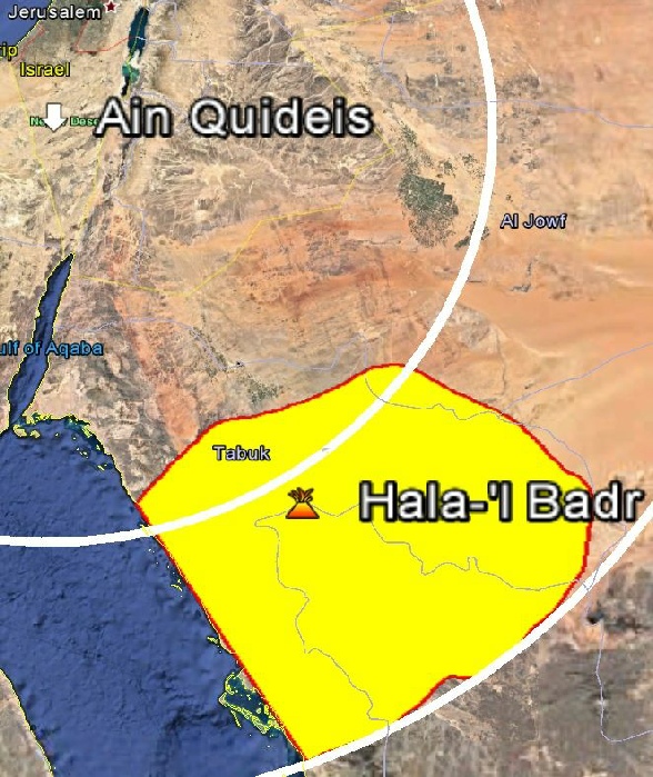
In that area are just 3 volcanoes that were active in the last 10,000 years.
- Harrat Rahah which has a small cone.
- Hala-
’l- ’Ishqua has eruptions of about 300ft high. - Hala-
’l Badr is has eruptions of about 3 mile high.
Mt. Sinai is described as impressive, with fire and smoke visible from Egypt.
Only Hala-
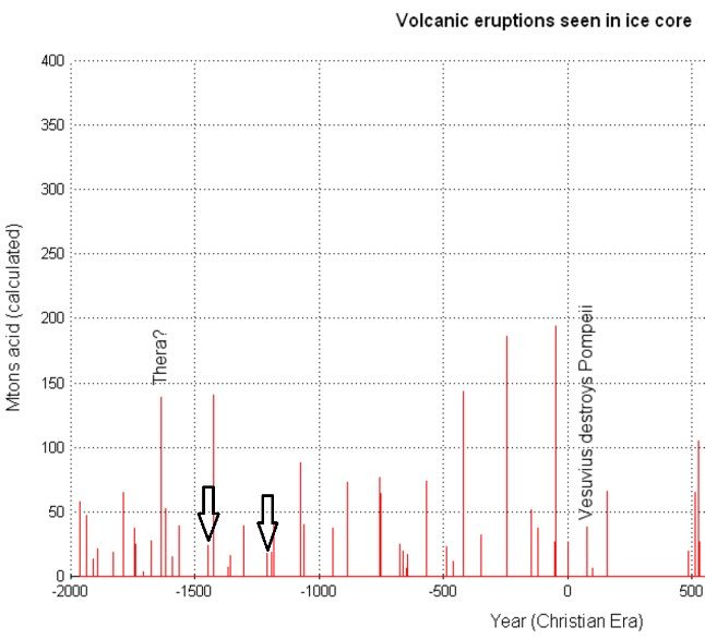
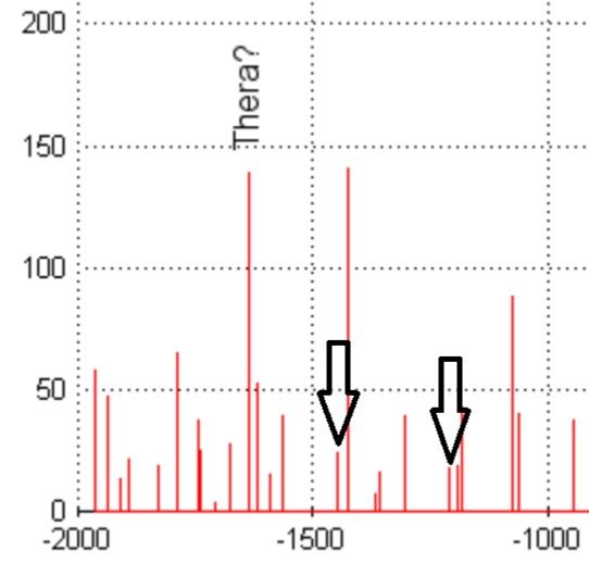
On this site you will find eruption data of Hala-
I measured the two eruption dates suggested on this and marked them with black arrows. An exact match for both 1211BC and 1446BC.
Unfortunately the only thing it proves is that volcanic eruptions took place in those years. Not which volcano.
3. The looks of Hala-
The 500ft high volcanic cone is located on flat sandstone table mountain with a 6 mile diameter. This table is surrounded by the fertile fields of the al-
So that’s plenty of space for camping and the flocks can be fed in the nearby fields.
The valley broadens out into a basin enclosed on all sides by low, but steep, slopes, and known as al-
The Northern Hegaz, p214.
A sandstone plateau is easy to walk on; far better that the lava fields surrounding the other volcanoes. The black basalt is sharp, slippery and get’s blazing hot from the sun.
The last mentioned stop before this location was the rock with water gushing out. It’s very well possible the table mountain they are standing on now is that rock. It does fit all the requirements mentioned on the previous page:
- Porous -
The sandstone table is porous. - High for pressure -
The table is very high. - Big enough to store water for people and flocks -
The table is massive. - Soaks up rain -
Rain falling on the table will be slowly absorbed.
Deut 9:21 I took your sin, the calf you had made, and burned it up in the fire, beat it to pieces, and ground it up still smaller, until it was as fine as dust; then I threw its dust into the stream coming down from the mountain.
Upon the eastern slope of the gray table mountain of Tadra is situated the black volcano Hala’-
The Northern Hegaz, p214.
A stream, another match.
Exod 19:14 And Moses went down from the mount to the people, and sanctified the people; and they washed their clothes.
More of the same, but I think it’s worth pointing out that all people washing their clothes means an abundance of water. Which of the other suggested locations has that much water?
To the southeast we perceived the hill of Slej' and still farther in that direction the volcano of al-
The Northern Hegaz, p214.
Moses is also part of the islamic religion and a well in the city of Midian is named after him. The al-
4.Mt. Sinai located.
Detailed map on the last page of this site.
- Hala-
’l Badr is in the right area. - Hala-
’l Badr’s eruption is of the correct type. - Hala-
’l Badr erupted during the proposed Exodus times. - Hala-
’l Badr is surrounded by field for grazing. - Hala-
’l Badr had a stream flowing down from it. - Hala-
’l Badr had plenty wells with drinkable water. - Hala-
’l Badr had enough water to wash 20,000+ clothes. - Hala-
’l Badr