


This page was last updated on 13 July, 2017.
1. Fact and fantasy
Books, articles and documentaries about Mt. Sinat can be roughly divided into three groups:
- Scams. Fabricated stuff to promote doctrine. (Jewish, Christian, secular, muslim)
- Amateurism. Well meant but unprofessional conclusions.
- The real deal.
Sinai Peninsula was extensively searched by archeologists Rothenberg in 1970 and Beit-
Nowhere in Sinai did we or our colleagues find any concrete remains of the stations on the Exodus route, nor even small encampments that could be attributed to the relevant period. Neither did we discover anything that would help us identify the Mountain of God. So the enigma—and the challenge—remain.
The el-
The main source of info is rather old. From the time before those mountains were linked to being mt. Sinai. Then it suddenly became a religious affair.
But still some more recent info is available, not from archeologists but geologists searching for possible oil fields.
2. Jabal al-
Midian was in situated the Northern Hegaz, which means ‘the barrier’, ‘the divide’ or ‘the cord’. The meaning of that is readily understood when looking at a map. That cord of mountains extends 800 miles south from the eastern tip of the Gulf of Aquba.
Jabal al-
- Radar Peak 2393m→ Named after a military radar station.
- Jabal al-
Lawz 2580m → Mountain of almonds (almond trees grow there) - Main Peak of Jabal al-
Maqla 2368m → Mountain of the quarry (marble) - Lesser Peak of Jabal al-
Maqla 2285m - Jabal Umm Hayfa 2362m → Mountain of mother rock.
2a. Jabal al-
The Jabal al-
he ascended up to Mount Sinai, which is the highest of all the mountains that are in that country and is not only very difficult to be ascended by men, on account of its vast altitude, but because of the sharpness of its precipices also; nay, indeed, it cannot be looked at without pain of the eyes: and besides this, it was terrible and inaccessible, on account of the rumor that passed about, that God dwelt there. But the Hebrews removed their tents as Moses had bidden them, and took possession of the lowest parts of the mountain; a
Josephus, Antiquities of the Jews, Book 3, chapter 5, section 1
2b. Jabal al-
This peak is far more accessible than the al-
2c. Pro and con
- Jabal al-
Lawz - Highest → Pro → See Note #1
- Very hard to access → Pro → Note #2
- No archeological finds → Con
- Jabal al-
Maqla - Many archeological finds → Pro
- Far easier to access → Con → See Note #1
- Not the highest → Con → See Note #2
- Note #1
This peak most certainly reaches highest into the sky. But when standing in the area that’s not so obvious because the al-Lawz peak is largely obscured by it’s foot mountains.
The peak itself is less high because it stands on a plateau. So I’m suggesting that possible the ‘highest mountain’ should be understood as ‘what looks like the highest peak’. - Note #2
Moses would surely have climbed any mountain God ordered him. But the when God spoke to Moses from the burning bush, Moses went up that mountain voluntarily with his sheep. Moses was told to get the people from Egypt and take them to the mountain he was standing on right then.
Would Moses go up a mountain that “cannot be looked at without pain of the eyes”?
What’s the correct mountain? You decide…
I won’t discuss Jabal al-
3. Requirements
The mountain can only be found by some detective work. And the first step is to make a list of ‘properties’ needed to qualify as mt. Sinai.
- Highest peak.
- Jabal al-
Lawz: Yes - Jabal al-
Maqla: No
- Hard to climb.
- Jabal al-
Lawz: Yes - Jabal al-
Maqla: No
- Somewhere in or near Midian. Fairly close where Jethro lived.
- Jabal al-
Lawz: Yes - Jabal al-
Maqla: Yes - Note: The Bible never claims the mountain was in Midian. It only states Moses lived in Midian and grazed his sheep in the wilderness. Not that the wilderness was within Midian’s borders.
- Good fields to graze sheep.
- Jabal al-
Lawz: ??? - Jabal al-
Maqla: Yes
- Sufficiently big to camp.
- Jabal al-
Lawz: ??? - Jabal al-
Maqla: Yes
- Water and food to sustain both man and animal for 11 months
- Jabal al-
Lawz: ??? - Jabal al-
Maqla: Yes
- A stream
- Jabal al-
Lawz: ??? - Jabal al-
Maqla: Yes - Deut 9:21 And I took your sin, the calf which you had made, and burnt it with fire, and stamped it, and ground it very small, even until it was as small as dust: and I cast the dust thereof into the brook that descended out of the mount.
- Accessibility and distance. It took them 2 months to reach the place so distance is a factor too.
- Jabal al-
Lawz: Yes - Jabal al-
Maqla: Yes
4. Roads & Rivers
It comes as no surprise there were no asphalt road in the mountains in Moses’ time. In fact there were no manmade roads at all. Everything that can be classified as a road, route or other similar names was made by nature.
In that mountain area the roads were and still are streambeds of rivers. I’m not saying people walked waste deep in rivers all the time. Far from. The riverbeds are most of the time completely dry.
There isn’t an abundance of (dry) rivers and certainly not big enough ones to act as a road for all the Israelites and their flocks.
So, it very likely, not to say a fact, that walked trough or very near the streambeds. As water always flows down the major streambeds are found in valley like area’s. Valleys often the most suited places for camping.
As we know Moses went up the mount several times. I think it’s safe assume nobody assumes Moses climbed the mountain like a mountain climber with a pickaxe and ropes. No, very likely he took a ‘road’ going uphill. Meaning a streambed of a river.
‘Wadi al-
The hills are very steep. Mostly ranging from very hard to totally impossible to climb without tools. Also keep in mind, while Moses was in good health he was 80+ years old.
So, the most obvious route up a mountain is through a streambed. That would be stream running from the mountain peak in the west down to the Wadi al-
I’m not in any way implying there is just one (usable) uphill road in that area but the ‘Maqla Ravine’ is a good candidate. The main reasons are:
- In the correct region.
- It’s a good road uphill road
- That uphill road is well reachable by the highway
- Lot’s of artifacts found near the road.
- Large camping area.
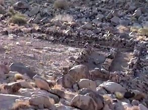
5. Archeological finds
The main problem as stated before is that the Saudi don’t allow (serious) archeological work. But still some conclusions can be drawn from photo’s taken with a tele-
- Cemetery
There is an unusual large cemetery for a region with just a few nomads.
But the many Israelites were killed by God, and that could explain the many graves. - Chain wells
Abnormally many and big chain wells of high grade workmanship. Built to last. Very odd for an area that was never inhabited besides a few passing nomads.
But the many Israelites fro the Exodus had great water requirements. - Split rock
- Stone altar
Something that looks like a huge stone altar was found. Again clearly the work of a large group. To large and labor intensive to be built by a few passing by nomads.
Location: T-junction of the uphill ‘Maqla Ravine’ and ‘Wadi al- Abyad’ highway. - 12 marble pillars
12 marble pillars, thought to represent the 12 tribes were found in that area.
The Saudi ‘archeologists’ try to wave away that find by claiming it was a marble quarry. But that’s very likely nonsense because the quarry is very remote and the amounts of marble far to small.
Exodus 24:4 Moses then wrote down everything the Lord had said. He got up early the next morning and built an altar at the foot of the mountain and set up twelve stone pillars representing the twelve tribes of Israel. Then he sent young Israelite men, and they offered burnt offerings and sacrificed young bulls as fellowship offerings to the Lord. Moses took half of the blood and put it in bowls, and the other half he splashed against the altar.
- Burned mountain
The peak of the mountain looks like it was burned by extreme heat. The heat of God’s presence some claim. But both geology and chemistry can explain the ‘scorched’ peak. It’s completely natural and not very rare.
The blackened color of the top of Gebel el-
ibid. 134.
Altar
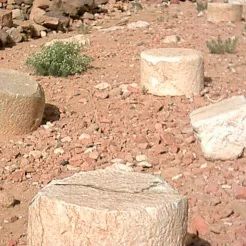
Pillars
Exodus 24:4 Moses then wrote down everything the LORD had said. He got up early the next morning and built an altar at the foot of the mountain and set up twelve stone pillars representing the twelve tribes of Israel.
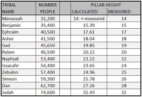
The pillars on the photo look more than stumps instead of pillars. But there is something interesting about them. They have varying lengths that possibly correspondent to the size of the 12 tribes. The calculation is as follows:
<Tribe number> / 32200 x 14 = calculated.
The rounded numbers aren’t always exactly what’s found in the field; but amazingly close. The pillars where organized in a square as on a priest’s breastplate.
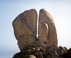
Split rock
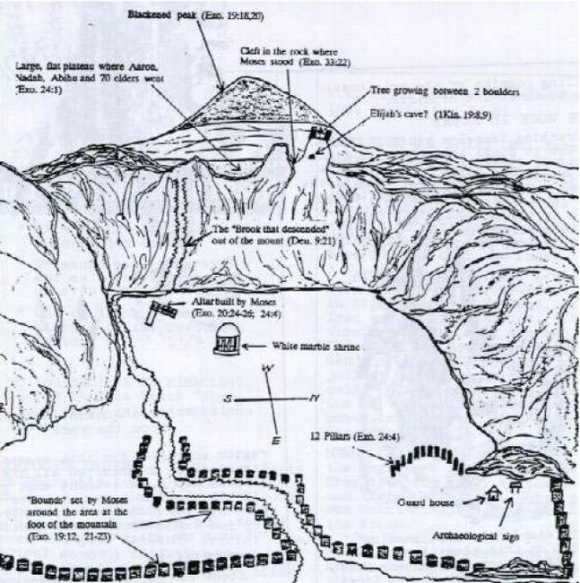
“Holy Precinct.” Jonathan Gray
The tree between the boulders is an almond tree. The Menorah God ordered Moses to make, has many features of an almond tree. Perhaps coincidence, perhaps not. Was there even a tree, 3500 years ago?
6. Moses’ original route
Needless to say, when Moses fled to Midian 40 years before the Exdodus he didn’t went trough the Red Sea but took the road over the tip if the Gulf of Aqaba.
From that tip a road runs far south. Presently frequently used by muslim pilgrims. That road combined with 2 other major roads and a minor one easily leads to mount Sinai.
After they crossed the Red Sea they had to walk along the shoreline to the north and were back on the main road. South was no option because it’s blocked by high mountains.
7. Conclusion
- Nothing about ‘Jabal al-
Maqla’ contradicts the Bible. - ‘Jabal al-
Maqla’ contradicts some points of Josephus account. - The network of roads makes ‘Jabal al-
Maqla’ a plausible candidate. - The artifacts increase that plausibility.
- The spacious camping area at the foot of the mountain again adds to that plausibility.
- The area is well watered.